Know which plants need you this quarter.
Every plant with a federal discharge permit, mapped with exactly what it was out of compliance on and when, its enforcement history, and the person who signs its reports. Plan the trip, then get a weekly email when something new happens in your territory.
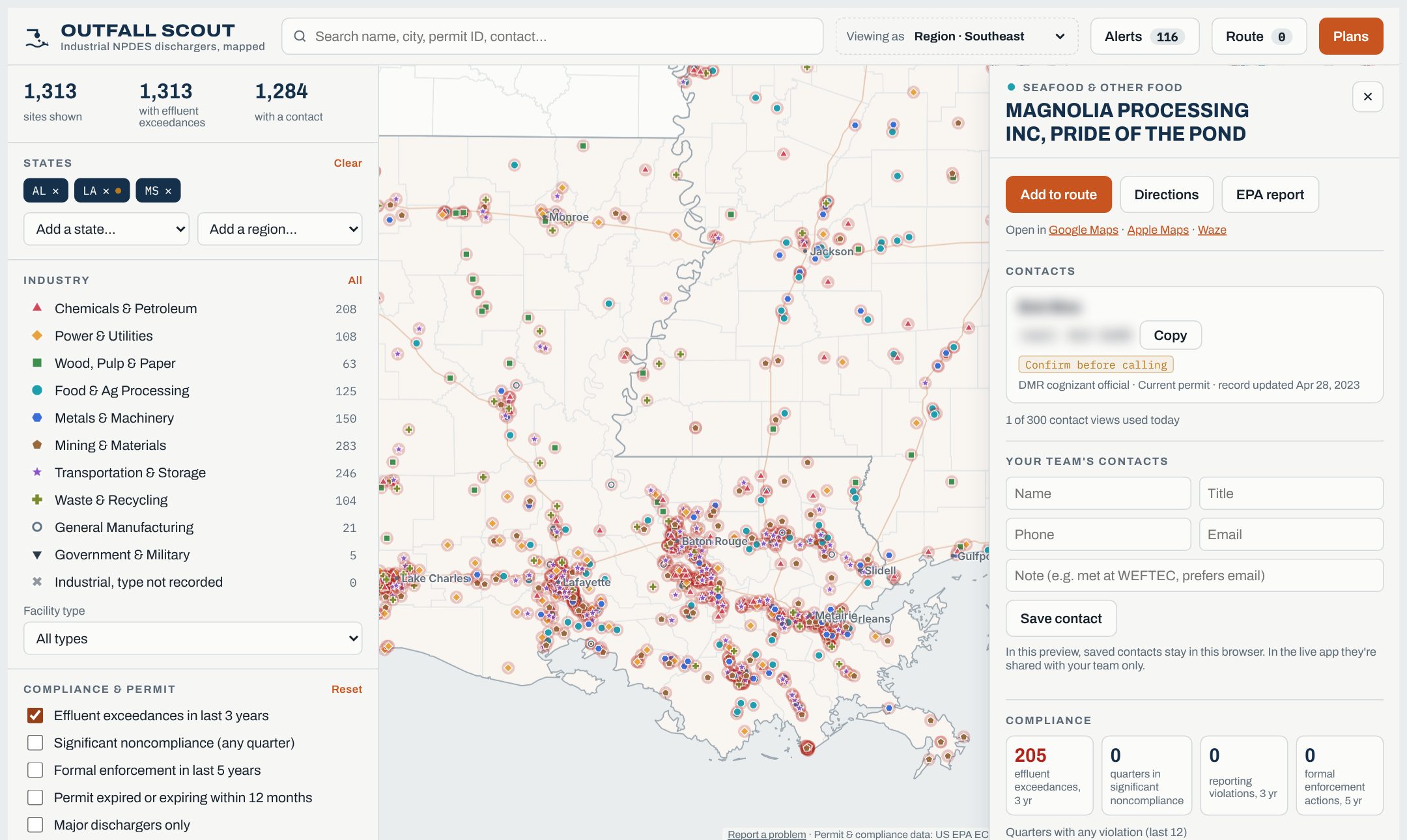
What's out of compliance near you?
Enter a ZIP code. We'll count the industrial plants around it that went over a permit limit, straight from EPA's latest records.
- –
- plants exceeded a permit limit in the latest quarter
- –
- exceeded a limit at least once in 3 years
- –
- had a formal enforcement action in 5 years
- –
- industrial dischargers in all, plus – municipal plants
Search, book, route, calendar
A real trip around Mobile, Alabama: find the plants that went over a limit, see exactly what failed, call the person on the report, and put four visits on the calendar.
Contact details in the video are replaced with placeholders and blurred.
From a quick search to a meeting
EPA's permit and compliance records are public, but scattered and hard to use. We clean them, match them to the right facility, and add who to call. We do the digging, so you spend your time selling instead of searching.
Every permitted outfall
Filter by state, industry (pulp mills, poultry, power by fuel type and 40 more), permit type and size, with municipal plants a click away. Locations are checked against county lines, not taken on faith.
What was out of compliance
Every limit the plant exceeded: the parameter, the month, the limit, what it reported and how far over. Plus noncompliance, enforcement and expiring permits.
The person on the report
The official who signs the site's Discharge Monitoring Reports, plus state-permit, TRI and hazardous-waste contacts, each with its source and date.
Route and schedule it
Pick up to ten stops, get the shortest order and drive times, and add the whole trip to Outlook, Google or Apple Calendar.
Built for people who sell to plants
If your product, service or expertise helps a plant meet its permit, the plants that are missing theirs are your best leads.
Equipment makers, reps and distributors
Analyzers, pumps, aeration, filtration, controls. Find plants out of compliance on the parameter your product measures or fixes, and plan the week's visits around them.
Water treatment chemical companies
See which food, metals and chemical plants are struggling with their limits and who signs off on their reports. Build a territory list in minutes.
Environmental consultants and engineers
Enforcement orders and expiring permits are new projects. Weekly alerts tell you about them before a competitor calls.
Testing labs
Every permit holder has to sample and report. Find sites that file electronically, are nearby, and have reporting violations.
Walk in knowing exactly what failed
Every site card lists each limit exceedance from the last three years, newest first, straight from the plant's own discharge monitoring reports.
- The parameter: TSS, ammonia, pH, BOD, metals, toxicity and more
- The month, the outfall and the type of limit
- The limit next to what the plant reported, and how far over
- Search the map by parameter to find every plant failing on what you fix
- TSS Aug 2026 · outfall 001 · limit 32.23 kg/d, reported 36.05+12%
- TSS Aug 2026 · outfall 001 · limit 19.89 kg/d, reported 25.65+29%
- Oil & grease May 2025 · outfall 001 · limit 7.17 kg/d, reported 7.24+1%
- Phenolic compounds, total Nov 2024 · outfall 001 · limit 0.1 mg/L, reported 0.1+1%
- Sulfide, total Sep 2024 · outfall 001 · limit 0.32 kg/d, reported 2.85+783%
A fresh list of plants that need help, every Monday
Each week we compare EPA's new compliance data with last week's. You get only what changed in the states you cover.
- New effluent limit exceedances
- Sites newly flagged in significant noncompliance
- New formal enforcement actions and penalties
- Filter by industry, or turn off what you don't sell into
- Municipal sewage treatmentVicksburg, MS · 2026 Q3+16
- Municipal sewage treatmentBelzoni, MS · 2026 Q3+15
- Seafood & Other FoodTunica, MS · 2026 Q3+14
- Municipal sewage treatmentStarkville, MS · 2026 Q3+12
- Municipal sewage treatmentMarshall County, MS · 2026 Q3+11
Published prices. Per user. Cancel anytime.
Every plan includes the full map, every exceedance and what was out of compliance, contacts, weekly alerts and route planning for the area you cover. Try any plan free for 7 days.
There's no free version; book a demo to see it on your territory first. Regions: Southeast, South Central, Northeast & Mid-Atlantic, Midwest, Mountain and Pacific. Need several regions or more than 25 users? Ask about team pricing. Prices in US dollars, before any sales tax.
What people ask first
Where does the data come from?
All of it is public. Compliance and permit records come from US EPA's ICIS-NPDES system (through ECHO), including each plant's own discharge monitoring reports and permit limits. Contacts come from those reports, EPA's Toxics Release Inventory, hazardous-waste (RCRA) records and state permit portals. Locations are checked against US Census boundaries. Our work is cleaning, matching and keeping it current.
How often is it updated?
Permits, compliance and enforcement refresh every week, and alerts go out right after. Line-by-line exceedances, monitoring requirements and contacts are re-pulled monthly, when EPA posts them. State-portal contacts refresh quarterly. Each contact shows the date of the record it came from.
What does a site card show?
What the plant was out of compliance on and when: each parameter, month, outfall, limit, what it reported and how far over. It also shows what its permit requires it to measure, with how often and the limits. Plus noncompliance and enforcement history, permit dates, and who to call. You can filter the map by an exceeded parameter or by one the plant has to measure.
How accurate are the contacts?
They come from what the facility filed with its regulators, so they're as current as the filing. Each is labeled by age: Recent, Confirm before calling, or Likely outdated. Report a wrong one from any site card and we'll correct it for everyone.
Which sites are included?
Every state, DC and the territories. Industrial dischargers with an active, expired or administratively continued NPDES permit or general-permit coverage are included: manufacturing, mining, power, food processing, chemicals, landfills, ports and more. Municipal sewage plants are on their own layer you can turn on. Construction stormwater is left out.
How do violation alerts work?
Every Monday, paid subscribers get an email listing the sites in their plan's area with new exceedances, new significant noncompliance or new enforcement. You can choose which industries and alert types you get. The app also shows how many new violations happened in areas outside your plan.
Is there a free version?
No. Request a demo and we'll walk through your own territory with you, or start a 7-day trial of any plan. You can also try the ZIP code lookup above, no sign-up needed.
How does the trial work?
You get 7 days with the full map for your plan's area and up to 25 contact views a day. A card is needed to start, and you're only charged if you keep it past day 7. Cancel any time before then and you pay nothing. Each team gets one trial. Weekly alert emails start once the plan is paid.
Can my whole team use one account?
Each person gets their own sign-in, and you pay per user: 15% off at 5 users and 25% off at 10. A sign-in works on one device at a time, so signing in on a new device signs out the old one. Your team shares the contacts you add, and the owner adds or removes people from the billing page.
Who can see the contacts my team adds?
Only your team. We look at them only if you ask for support or the law requires it. We never use them for our own sales and never share them.
Can I take the data into my CRM?
The data stays in Outfall Scout, where it's updated every week, and there's no bulk export. You can copy a site's contact, add visits to Outlook, Google or Apple Calendar, navigate with Google Maps, Apple Maps or Waze, and save your team's own contacts on each site. Direct connections to Salesforce and HubSpot are on the roadmap.
How do billing and cancelling work?
Change plans, add or remove users, update your card or cancel any time from Account → Billing. If you cancel, you keep access until the end of the period you've paid for. If a payment fails, the map locks until the card is updated, then opens again as soon as the payment clears. Your saved contacts and settings are kept.
Do you track my location?
No. Near me uses your device's location only to center the map, and it's never saved. The ZIP lookup on this page only counts plants; it doesn't store what you type.
See your territory in 20 minutes
Tell us what you sell and where. We'll show you the plants that need it, why now, and who to ask for.